
If you manage a fleet in Australia, you have probably already seen geofencing as a feature listed somewhere inside your tracking platform. Maybe you switched it on. Maybe you didn’t. But here is what a lot of operators miss: geofencing for fleet management is not just a “nice to have” feature for seeing dots move on a map. In 2026, it has become one of the most practical tools you can use to build compliance evidence, protect your assets, and keep the NHVR off your back.
The amended Heavy Vehicle National Law (HVNL), which kicked in on 1 August 2026, now requires every Chain of Responsibility (CoR) party to maintain a documented Safety Management System (SMS). That system gets assessed against the PSOE standard (Present, Suitable, Operating, Effective). The NHVR does not specifically mandate geofencing. But the kind of evidence geofencing produces, things like timestamped boundary crossings, speed-zone alerts, dwell-time logs, and after-hours movement records, is exactly what an auditor wants to see when they are checking whether your safety controls are genuinely working day to day.
This guide walks through how geofencing works in a fleet context, the specific compliance and safety benefits it delivers for Australian operators, and how to set it up without drowning in false alerts.
What Is Geofencing and How Does It Work in Fleet Management?
In simple terms, a geofence is a virtual boundary you draw around a real-world location on a digital map. When a GPS-equipped vehicle or asset crosses that boundary (entering or exiting), the fleet management system logs the event and triggers whatever action you have set up. That could be a push notification to you, an alert to the driver, an automated timesheet entry, or a compliance record filed against the vehicle’s trip history.
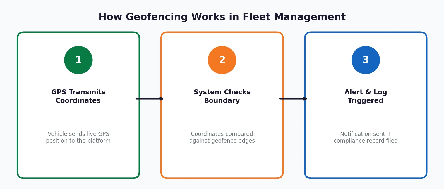
The technology behind it relies on GPS satellite trilateration, which is the same positioning method that powers real-time fleet tracking. Your fleet software takes the vehicle’s live GPS coordinates and compares them against the stored coordinates of each geofence boundary. The moment coordinates overlap, the system registers an event.
There are three common geofence shapes you will see in fleet operations:
- Circular (radius-based): You pick a centre point and set a radius. Quick to set up for depots, fuel stops, and customer sites. Works well when you do not need pinpoint accuracy at the edges.
- Polygon (custom-shaped): A multi-point boundary that follows the exact outline of a site. Think construction zones, mining pits, or loading docks. Essential for sites where a few metres actually matter.
- Corridor (route-based): A band drawn along an approved route. The system alerts you when a vehicle strays outside the corridor. Useful for hazardous goods transport or fixed-route linehaul.
For most Australian fleet operations, you will end up using a mix of all three depending on the site.
Why Geofencing Matters for Australian Fleet Compliance
Chain of Responsibility (CoR) Evidence
Under the HVNL’s Chain of Responsibility framework, every party with control or influence over a transport activity shares a legal duty to ensure safety so far as is reasonably practicable. That includes operators, schedulers, consignors, and loading managers. The NHVR’s 2026 Master Code identifies over 500 recommended controls across 45 transport activities. While the Master Code is not legally mandatory, courts can and will reference it as a benchmark for what “reasonably practicable” looks like in practice.
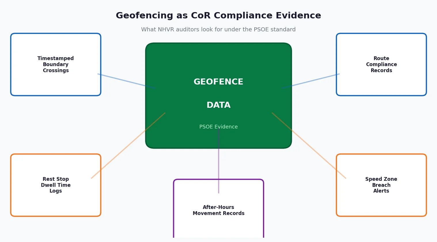
So where does geofencing fit? It directly supports several of those controls:
- Speed management: A geofence with a speed threshold logs every instance a vehicle exceeds the limit within a defined zone. School zones, urban areas, on-site speed limits at mine sites or construction yards. That timestamped record is CoR evidence showing you were actually watching, not just hoping for the best.
- Route compliance: Corridor geofences prove that vehicles stuck to approved routes. This matters most for dangerous goods transport or routes that need to avoid restricted roads.
- Loading and dispatch: Geofences around loading bays and dispatch points record arrival and departure times. If a fatigue or scheduling dispute comes up later, those records support a “reasonable steps” defence.
Without this kind of data, an operator facing an NHVR audit is going to struggle to show that their safety controls were anything more than policy documents sitting in a filing cabinet. The PSOE framework specifically tests whether controls are “Operating” (being used day to day) and “Effective” (actually producing the intended safety outcome). Geofence logs are one of the clearest ways to pass both of those tests.
Safety Management System (SMS) Integration
The amended HVNL requires a documented SMS. Geofencing feeds directly into three of the five SMS outcome areas the NHVR assesses:
- Speed management: Zone-specific speed alerts and historical compliance rates over time.
- Fatigue management: Dwell-time data at rest stops, cross-referenced against driver work and rest hours. This verifies that rest breaks actually happened where and when they were recorded.
- Vehicle maintenance: Automated service triggers when a vehicle enters a designated maintenance bay, creating a timestamped record that feeds into your fleet maintenance schedule.
Workplace Safety Obligations
Vehicle incidents are still the number one killer in Australian workplaces. According to Safe Work Australia’s Key WHS Statistics 2025 report, vehicle incidents accounted for 42{a1ecdeac7aa669694223042b5414f4ebc99bf67e8f4841ec62bf1bd690e4433f} of all worker fatalities in 2024. Trucks and semi-trailers featured prominently, and males made up 94{a1ecdeac7aa669694223042b5414f4ebc99bf67e8f4841ec62bf1bd690e4433f} of vehicle-related deaths. The WHS Act defines a vehicle as a workplace, so the PCBU duty of care applies every single time a driver is behind the wheel.
Geofencing supports WHS compliance by flagging hazardous zone entries, enforcing site-specific speed limits, and generating the evidence trail that shows you were actively managing risk. That is the core requirement under both the WHS Act and the HVNL.
Practical Use Cases for Australian Fleets
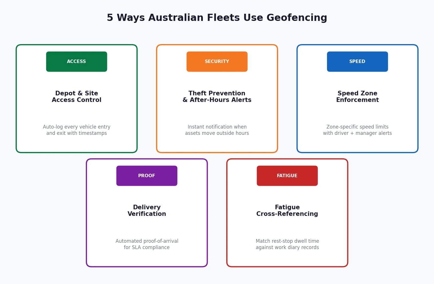
1. Depot and Site Access Control
Draw a polygon geofence around your depot, warehouse, or customer site. Every vehicle entry and exit gets automatically logged with a timestamp, driver ID, and vehicle ID. No manual sign-in sheet needed. This is especially valuable for government fleet operations where audit trails and accountability standards are strict by default.
2. Theft Prevention and After-Hours Alerts
Set a geofence around your yard or equipment storage area and configure an alert for any movement outside business hours. If a vehicle or piece of tracked equipment crosses the boundary at 2 a.m., you get an instant notification. For mining and construction operators managing high-value assets across remote sites, this kind of security layer is not optional. It is essential.
3. Speed Zone Enforcement
Create geofences with embedded speed thresholds around school zones, residential areas, or on-site restricted zones. When a vehicle exceeds the set limit inside the geofence, both the driver and the fleet manager get an alert. The event is logged as a compliance record. Over time, this data builds a reckless driving monitoring profile that supports targeted driver coaching instead of blanket penalties.
4. Customer Delivery Verification
Geofence your customer delivery points to automatically record proof-of-arrival times. This eliminates arguments over late deliveries, supports SLA compliance, and cuts down on the volume of manual ETA enquiry calls your office handles every day. One Australian distribution operator reported that daily ETA enquiry calls dropped from over 40 to fewer than 10 after deploying proximity geofences with automated SMS notifications.
5. Fatigue Cross-Referencing
Geofence designated rest areas and then cross-reference dwell-time data against EWD or work diary records. If a driver’s logbook shows a 30-minute rest break at a particular location, the geofence data should confirm the vehicle was actually stationary at that location for the same period. When the two do not match, that flags a potential false entry, which is a serious red flag in any compliance audit.
How to Set Up Fleet Geofencing Without Alert Fatigue
Alert fatigue is the number one reason geofencing implementations fail. Too many geofences triggering too many notifications. Managers start ignoring them. Then the whole system becomes useless. Here is how to avoid that.
Start With High-Value Zones Only
Begin with the locations that carry the highest compliance or financial risk. Your home depot, your top 10 customer sites, any restricted or hazardous zones, and designated rest stops on your major routes. You can always expand later. Do not try to geofence everything on day one.
Match the Geofence Shape to the Site
Use circular geofences for simple locations like fuel stops and small depots. Use polygon geofences for complex or irregularly shaped sites like construction zones, mine pits, and large warehouses with multiple entry points. Getting the shape wrong is a common source of false boundary-crossing alerts.
Set Meaningful Thresholds
A geofence alert should trigger an action, not just fill up your notification tray. Configure speed thresholds, dwell-time minimums, and after-hours windows that match your actual operational rules. If your site speed limit is 15 km/h, set the threshold at 15 km/h. Do not set it at 10 km/h, because that will generate constant false positives from vehicles manoeuvring at normal crawl speed.
Layer Geofencing With Your Existing Systems
Geofencing delivers the most value when it feeds into your broader fleet management software rather than running as a standalone tool. Integrated systems connect geofence events to maintenance schedules, driver scorecards, IVMS data, and compliance reporting dashboards. That gives you a single, auditable view of every vehicle’s operational and compliance history.
Review and Prune Quarterly
Geofences go stale. Customer sites close, projects end, routes change. Set a quarterly review to deactivate or adjust geofences that no longer match your operations. This keeps alert volume manageable and your compliance data clean.
Geofencing for Fleet Management: Real-Time Tracking vs. Passive Logging
Not every fleet tracking system handles geofencing the same way. The distinction between real-time GPS tracking and passive GPS tracking is important here.
Real-time tracking with geofencing sends you instant alerts the moment a boundary is crossed. This lets you intervene immediately, whether it is a stolen vehicle, an unauthorised after-hours movement, or a speed-zone breach that needs addressing before the driver reaches the next site.
Passive tracking with geofencing logs boundary events for later download and review. That is fine for historical reporting and audit evidence, but it cannot help you prevent an incident that is happening right now.
For compliance-critical operations under the HVNL, particularly those subject to NHVR audits or operating under the Heavy Vehicle Accreditation (HVA) scheme, real-time geofencing is the practical standard. The PSOE audit method assesses whether controls are “Operating” in real time, not just documented after the fact.
The Cost Factor: What Geofencing Adds to Fleet Tracking
Geofencing is typically included as a standard feature within GPS fleet tracking platforms. It is not usually billed as a separate add-on. The real cost is not the technology itself. It is the setup time, the integration with your existing workflows, and the ongoing management of geofence zones.
If you are already running a fleet management system with GPS tracking, activating geofencing is a configuration exercise, not a new investment. The return shows up in reduced manual reporting, fewer disputed deliveries, stronger CoR audit evidence, and faster response to security events.
FAQ
What is geofencing for fleet management?
Geofencing for fleet management is the use of GPS-defined virtual boundaries around locations on a digital map. When a fleet vehicle enters or exits a geofenced zone, the system automatically logs the event and can trigger alerts, compliance records, or workflow actions.
Is geofencing mandatory under the HVNL in Australia?
No. The HVNL does not mandate geofencing by name. However, the amended HVNL (commenced 1 August 2026) requires a documented Safety Management System assessed against the PSOE standard. Geofencing data provides the kind of operating evidence that NHVR auditors look for when checking whether your safety controls are genuinely active and effective.
How does geofencing support Chain of Responsibility (CoR) compliance?
Geofence logs create timestamped records of vehicle movements, speed-zone compliance, site arrivals and departures, and rest-stop dwell times. These records directly support the “reasonable steps” defence under the HVNL and demonstrate active operator oversight, which is a key element the NHVR assesses during CoR investigations.
Can geofencing prevent fleet vehicle theft?
Geofencing on its own does not physically stop theft. But it enables immediate detection. An after-hours boundary-crossing alert notifies the fleet manager the moment a vehicle or asset moves outside an authorised zone, which means a faster response and significantly better recovery odds.
How many geofences should a fleet set up?
Start with your highest-risk and highest-value locations: home depots, major customer sites, restricted zones, and designated rest areas. The most common implementation mistake is creating too many geofences too quickly, which leads to alert fatigue and managers tuning out. Expand gradually based on operational need and review your geofence map every quarter.