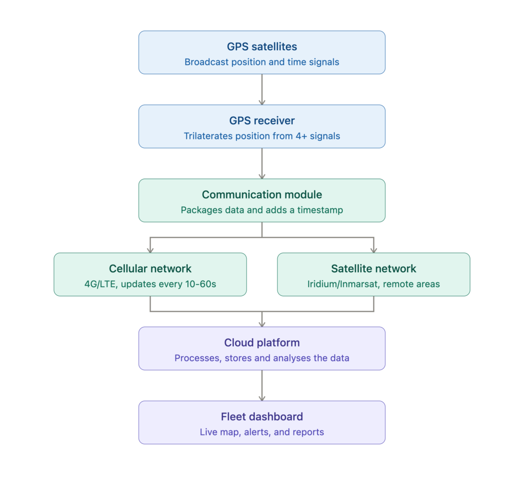
Quick answer: A GPS tracker installed in a vehicle receives signals from satellites orbiting Earth, calculates its position using the time difference between those signals, and then transmits that position over a cellular or satellite network to cloud-based software. The fleet manager sees every vehicle’s location, speed, route history, and driver behaviour on a dashboard or mobile app.
That is the short version. Below is the full technical breakdown: what the data actually captures, how it feeds Australian heavy vehicle compliance, and what the law says about tracking your drivers.
How GPS Determines a Vehicle’s Location
GPS stands for Global Positioning System, a network of approximately 31 active satellites operated by the United States Space Force, orbiting roughly 20,200 kilometres above Earth. Each satellite continuously broadcasts a signal containing its precise position and the exact time the signal was sent.
A common misconception is that the tracker in your vehicle sends signals up to those satellites. It does not. The tracker is a receiver. It listens to satellite signals, measures how long each signal took to arrive, and converts that time delay into a distance. To pinpoint a position in three dimensions (latitude, longitude, and altitude), the receiver needs signals from at least four satellites simultaneously. This process is called trilateration.
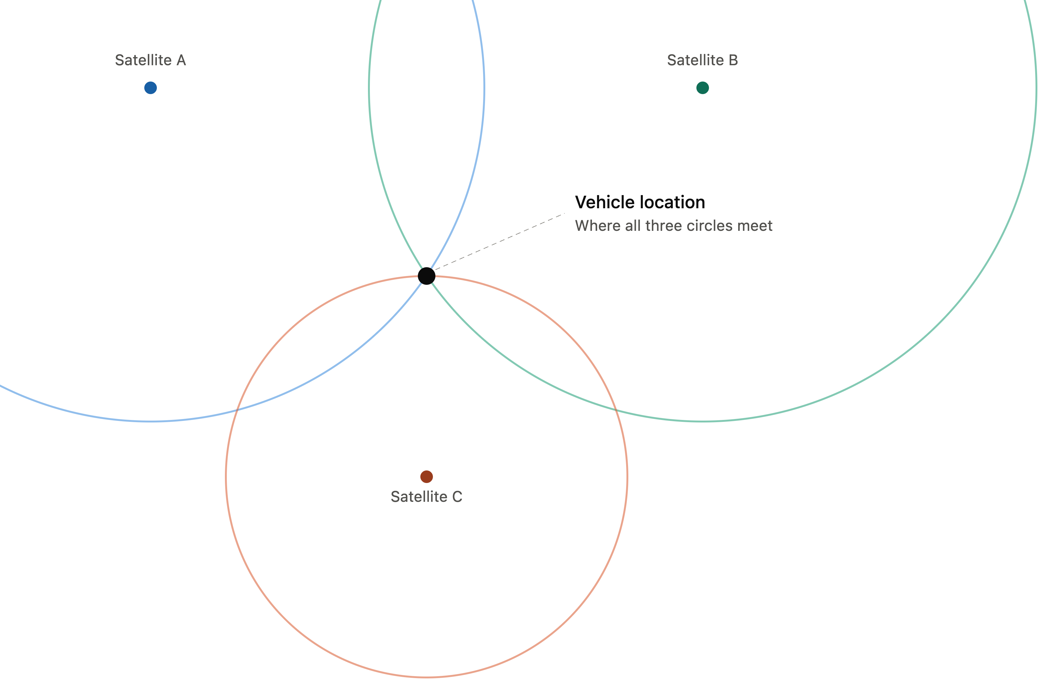
The U.S. Federal Aviation Administration’s technical standard puts basic GPS accuracy at approximately 7 metres, 95{a1ecdeac7aa669694223042b5414f4ebc99bf67e8f4841ec62bf1bd690e4433f} of the time, anywhere on or near the Earth’s surface. In practice, a well-positioned fleet-grade receiver in open sky conditions can achieve 3 to 5 metre accuracy. Urban canyons (tall buildings on both sides of a street), heavy tree cover, tunnels, and underground parking degrade that accuracy or block the signal entirely.
For Australian fleet operators running vehicles across metro, regional, and remote areas, GPS satellite coverage itself is not the problem. The satellites cover every square metre of the continent. The challenge is what happens after the tracker calculates its position: getting that data back to you.
How the Tracker Sends Data to Your Dashboard
The GPS receiver determines the vehicle’s position. A separate communication module then transmits that data to a cloud server. These are two distinct systems working together inside the same device.
- Cellular (4G/LTE). Most fleet trackers use a SIM card and the mobile network to transmit location data. In metro and major regional areas across Australia, this delivers near-real-time updates, typically every 10 to 60 seconds depending on the device configuration. The tracker packages each position fix with a timestamp, speed, heading, and any sensor data (ignition status, harsh braking events, engine diagnostics), then sends it to the platform’s servers.
- Satellite communication. For vehicles operating in areas without cellular coverage, such as inland freight corridors, remote mining sites, or outback pastoral stations, a satellite-enabled tracker sends data via satellite networks like Iridium or Inmarsat. This costs more per data point and updates less frequently, but it provides coverage where cellular cannot.
- Store-and-forward. Some trackers store position data locally when cellular signal drops and upload the stored data once the vehicle returns to coverage. This means you get a complete route history, but it is not truly real-time during the coverage gap. For a 20-vehicle fleet running Adelaide to Perth, for example, you may see live positions across the Nullarbor only if you are using satellite-capable devices. A cellular-only device will show a gap through the coverage dead zone and backfill the route history when the truck hits coverage again on the other side.
Manage Vehicle’s GPS tracking platform supports both cellular and satellite data feeds, so operators running mixed metro and regional routes see all their vehicles on one dashboard regardless of coverage conditions.
What Data a GPS Tracker Actually Captures
A basic consumer tracker records location and speed. A fleet-grade tracking system captures significantly more. The specific data points depend on the device, its installation, and the vehicle systems it connects to.
- Location and movement – latitude, longitude, speed, heading, and altitude at each reporting interval, creating a breadcrumb trail of everywhere the vehicle has been
- Ignition and engine status – whether the vehicle is running, idling, or switched off; idle-time reports identify vehicles burning fuel while stationary
- Driver behaviour events – harsh braking, rapid acceleration, sharp cornering, and speeding above set thresholds, each timestamped and GPS-tagged
- OBD-II and CAN-bus diagnostics – fault codes, fuel consumption data, odometer readings, and engine hours. Engine-hour data is particularly useful for scheduling maintenance on vehicles that idle heavily, since kilometre-based servicing intervals undercount actual engine wear
- Geofence triggers – virtual boundaries around depots, customer sites, restricted zones, or state borders, generating an alert when a vehicle enters or leaves
- Trip summaries – start time, end time, distance, duration, stops, and route for each trip, feeding proof-of-delivery, timesheet verification, and after-hours usage monitoring
All of this data flows to a centralised fleet dashboard where it can be filtered, reported on, and exported. For heavy vehicle operators, this is not just operational visibility. It is compliance evidence.
GPS Tracking and Australian Heavy Vehicle Compliance
For operators running vehicles over 4.5 tonnes GVM, GPS tracking data feeds directly into several Heavy Vehicle National Law (HVNL) compliance obligations.
Speed compliance. Under the HVNL Chain of Responsibility provisions, operators, schedulers, and consignors all share liability for speed breaches, not just the driver. GPS speed logs create a timestamped record showing whether vehicles operated within posted limits.
Fatigue management evidence. GPS data showing vehicle start times, stop times, and continuous driving duration provides a cross-check against work diary entries. If a driver’s diary shows a rest break at a location the GPS data places the vehicle in motion, that discrepancy becomes visible.
Maintenance scheduling. The amended HVNL, in effect from 1 August 2026, requires accredited operators to maintain a Safety Management System (SMS) that includes documented maintenance processes. Engine-hour and odometer data from GPS-connected telematics trigger service alerts based on actual usage rather than calendar estimates – the type of evidence NHVR auditors look for when assessing whether an SMS is operating effectively.
Geofencing as operator oversight. A geofence alert showing that an operator actively monitors where vehicles go, and responds when they deviate demonstrates the kind of proactive risk management the HVNL’s primary duty requires.
GPS data on its own does not guarantee HVNL compliance. But it provides the raw evidence that supports an operator’s ability to demonstrate “reasonable steps” under the primary duty. For the full compliance picture, see our guide on telematics and Chain of Responsibility.
Types of GPS Trackers Used in Australian Fleets
| Tracker Type | Best For | Power Source | Typical Use |
|---|---|---|---|
| Hardwired (OBD-II or direct wiring) | Permanent fleet vehicles: trucks, vans, utes | Vehicle battery | Real-time tracking, driver behaviour, engine diagnostics, compliance |
| Plug-in OBD-II | Light vehicles, short-term deployments | Vehicle OBD port | Quick install, basic tracking and diagnostics |
| Battery-powered (portable) | Trailers, containers, plant equipment, tools | Internal rechargeable or long-life battery | Asset tracking where no constant power supply exists |
| Solar-powered | Trailers, shipping containers, remote assets | Solar panel with battery backup | Long-term unattended asset tracking |
| Satellite-enabled | Vehicles in remote/regional areas without cellular coverage | Vehicle battery or standalone | Mining, agriculture, outback freight |
For heavy vehicle fleets, a hardwired tracker with CAN-bus integration is the standard. A common gap in heavy vehicle fleets is tracking the prime mover but not the trailer – if you’re running B-doubles or regular trailer swaps, each trailer needs its own tracker with its own compliance history for maintenance, location, and utilisation records.
GPS Tracking and Workplace Surveillance Law
GPS tracking of company vehicles is legal in every Australian state and territory, but it’s classified as surveillance, and each jurisdiction has its own rules around notice, consent, and how data can be used – NSW and the ACT have the most prescriptive requirements, including mandatory written notice periods and visible in-vehicle signage. Covert tracking without proper authorisation is unlawful and carries real penalties under state legislation.
Getting this right before you install a single tracker matters – see our full state-by-state guide to vehicle tracking laws in Australia for the specific notice, consent, and penalty requirements in each jurisdiction.
Choosing a GPS Tracking System for Your Fleet
The right platform depends on your fleet’s specific needs – reporting frequency, coverage in remote areas, integration with your compliance and maintenance systems, data hosting location, and hardware compatibility across a mixed fleet all matter more than any single headline feature.
For a full breakdown of what to evaluate and the questions worth asking any provider directly, see our guide to choosing the best GPS fleet tracking software in Australia.
FAQ
How accurate is GPS vehicle tracking?
Basic GPS accuracy is approximately 7 metres, 95{a1ecdeac7aa669694223042b5414f4ebc99bf67e8f4841ec62bf1bd690e4433f} of the time, per the FAA’s published technical standard. Fleet-grade trackers in open-sky conditions typically achieve 3 to 5 metre accuracy. Accuracy degrades in urban canyons, under heavy tree cover, and inside buildings or tunnels.
Can GPS tracking work without mobile signal?
The GPS receiver calculates position from satellite signals regardless of mobile coverage. What changes without a mobile signal is the ability to transmit that data in real time. Cellular-only trackers store data locally and upload it when coverage returns. Satellite-enabled trackers transmit via networks like Iridium, providing coverage across remote Australia at a higher per-data-point cost.
Is it legal to GPS track company vehicles in Australia?
Yes, in every state and territory, provided employees are properly notified – requirements vary by jurisdiction, with NSW and the ACT the most prescriptive. See our dedicated guide to vehicle tracking laws in Australia for the specific requirements in your state.
Does GPS tracking help with HVNL compliance?
GPS data supports several HVNL obligations: speed compliance evidence, cross-checking work diary entries against vehicle movement, maintenance scheduling based on actual engine hours, and demonstrating active fleet oversight through geofencing and alerts. It does not replace a documented Safety Management System, but it provides the underlying data that feeds into one.
How is a GPS tracker installed in a fleet vehicle?
Hardwired fleet trackers are typically connected to the vehicle’s OBD-II port, CAN-bus, or wired directly to the vehicle’s electrical system. Installation usually takes 30 to 60 minutes per vehicle and is best done by a qualified auto electrician or the tracking provider’s installation team. Plug-in OBD-II devices take seconds to install but are easier to remove, which may be a concern for fleet security.